


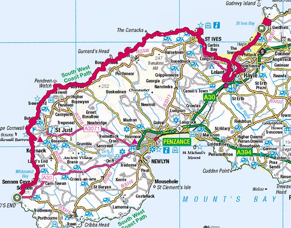
The Route
Godrevy
The rugged west of Cornwall
There is nothing I can say to prepare you for this course.
It will test you to the very limits.
I will give you a glimpse in these paragraphs of what to expect.
The race is mostly self navigated but with some marshals and additional signage in areas that are little more complicated
For the Ultras
You start at the Mile sign at Lands End.
Head of across the tarmac and pick up the trail at the First & Last House,
Follow this trail all the way into Sennen Cove, along the road then back onto the trail at the second car park.
You are on this undulating trail through the dunes and Gwynver Beach, across the sand!
You have a couple of miles of cliff trails until you reach Letcha Hill. DO NOT miss the left turn!
Follow the switch backs all the way down, DO NOT cut across.
This trail will then take you to Cot Valley, Climb out of Cot Valley up the road and look for the left to take you up the trail hill. Over this hill and then you will see Cape Cornwall. Follow the same route as the Arc. Down the hill, past the houses and then a very sharp, hard back left which takes you down to the bottom of the steps. Up those steps and turn right to go past the car park & toilets.
Left, onto the trail and follow this up and around before descending into Kenidjack Valley. Past the donkeys and turn left. 50 yards, then turn right up the hill towards the mines. Its a narrow trail and you come up onto a wide track. Turn left then look for the right turn, up again, after 50 yards
The trail is then twisty and turny through all the mines sections. Some of it is signed whilst other areas have had their signs stolen. Keep the sea on your left. Eventually, you cross a small stream on a wooden bridge. Follow the coast path around and up a steep hill. At the top, you will see Pendeen Lighthouse. Your scheduled first aid station is here
For the Marathon
You start in Pendeen Rovers home ground of Borlaise Park. Out you run along the gravel track before taking a left, down the road to Pendeen Lighthouse. This is your easy bit. A nice downhill road section to open your legs and stretch the field out before the narrow footpaths of the South West coast path.
The aid station here is for the Ultra runners
Follow the road around to the right, past your first lighthouse and down the steeper hill onto the path. You run down here for about 300 yards before turning off to the right onto the coast path proper.
You then have the longest half marathon of your life.
There are some tiny runnable bits. Apart from that, you will find, streams, mud, rocks to climb, steep downhills and many, many uphills. The first drink/feed station will be at Gurnard's Head
Important!
There are 2 short cuts, which will be marshalled this year.
Zennor Head, follow the footpath all the way round, DO NOT cut across the headland
Hor Point, about a mile after the trig pillar. DO NOT go over the hill that is straight ahead, follow the left turn that goes down. This is signposted with a granite stone
This brings you into St Ives.
Your second feed station will be at Porthmeor beach
You follow the streets through St Ives to The Island or St. Ives Head. Around the headland and down to Porthgwidden Beach and on round to St Ives harbour front. This is all along the official coast path. We will help you where we can but there are a fair few acorns out there as well to show the way. Through St Ives, look left, its your second lighthouse then past the lifeboat station and on to Porthminster. From there, you climb up to Hain walk and continue along the road towards Carbis bay. Down the path, through the hotel complex, up the awful road hill before turning left onto the coast path again. You stay on this path through trees, mud, more hills until you reach the dunes. Stay high up, near the railway track, over the footbridge on your right and around the golf course to St Uny's Church at Lelant. Here is your third water/feed station.
You may think you have done the worst of it. It is now the mind sapping section of Lelant to Black Rocks in Hayle. Miles of open road and Hayle town.
After the church, make sure you turn down left, onto Green Lane and The Saltings. Once you have gone a mile or so, do not miss the tiny left turn into Saltings Reach, Through the hedge and turn right into the estate then left onto the B3301, the main road into Hayle. This is a very busy and fast road, please treat it with respect. You stay on the footpaths (NOT THE ROAD) all the way into Hayle. This is the only deviation from the coast path signs. DO NOT go round Carnsew Pool. Stay on the straight path into Hayle and DO NOT go up onto the cycle path on your right. We won't disqualify you, it just means you are doing extra milage.
Round Hayle harbour, along the grass towards Philps. Follow the road round then turn left over the bridge and run along the main road of North Quay before following the dirt track road up to Black Rocks car park. This is your last water/feed stop before the finish.
You are now entering the infamous Dunes of Doom.
There are a lot of slate signs showing the way but if you are unfamiliar with the area, it can be tricky.
The map I have done and the gpx route follow the exact coast path. I mapped it using satellite images rather than the OS marked path.
Once you have survived the dunes, you reach Gwithian Towans car park.
Here is where the finish changes
You head down the coast path as normal and into St Gothian Sands. Follow the arrows and sawdust into the dunes. Down through to the lake where you turn right and head around the lake reserve before following the river back towards the coast. Continue to follow the arrows and sawdust up onto the ridge line after the river foot bridge. Run along the ridgeline, following the beach back in the direction towards Gwithian towans car park.
Off the beach, up on to the coast path and follow the arrow, turning left up the coastguards gravel road towards the chalets. Turn right on the tarmac and head to Sunset Surf Café
THE FINISH LINE!!
Marathon


Ultra

The route around St Ives

Finish 2026
